Atlantic Theater Map Conservation
Posted by Travis Davis on August 3, 2023

On behalf of our crew, our colleagues at Texas Parks and Wildlife Department’s (TPWD) Cultural Resources branch, and OnAim Conservation, I am pleased to announce that the stabilization, conservation, and partial restoration of the Atlantic Theater Map in the Captain’s Cabin is complete!
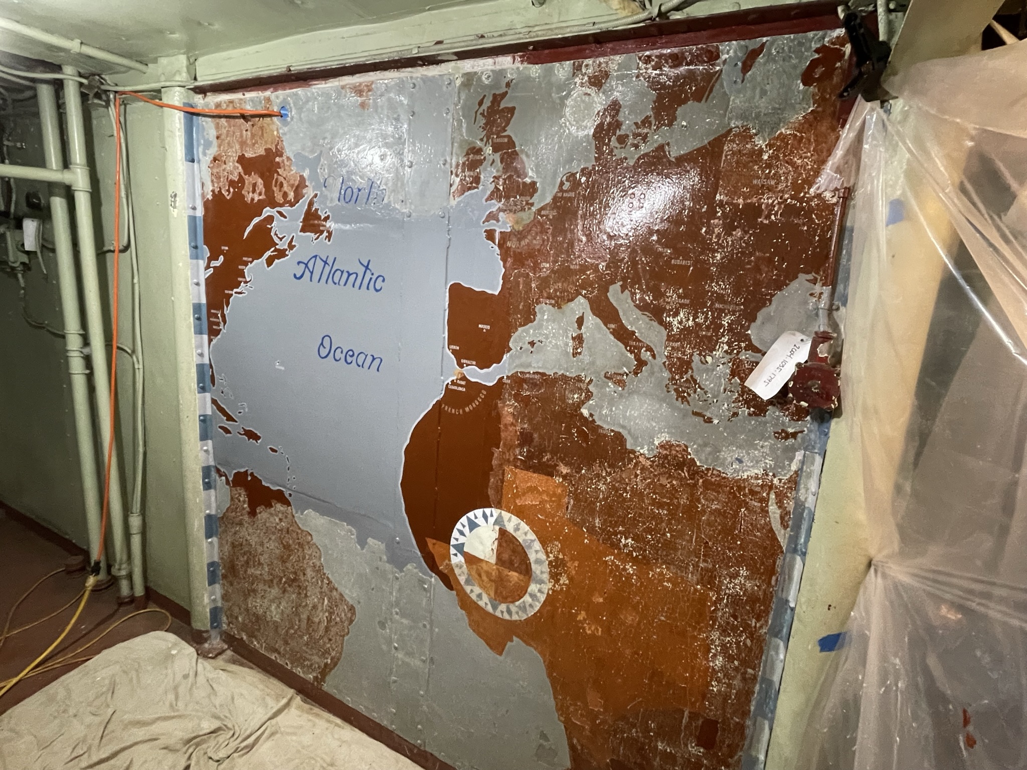
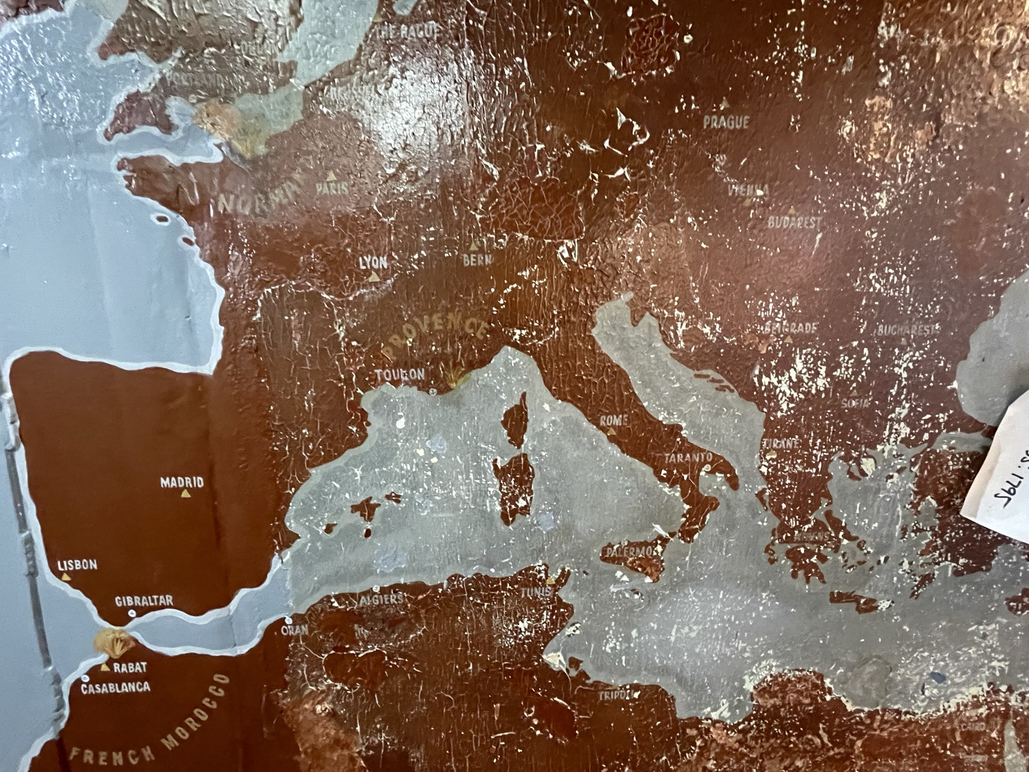
This map of the WWII Atlantic Theater was painted on a bulkhead in the Captain’s Cabin after September 1944 (based on references in the map). It shows the ports of call Texas made during WWII (white dots with anchors in them), where she performed shore bombardment (noted by little explosions), national capitals (yellow triangles), and a few surprise discoveries as the map was conserved.
Sometime after 1966 (which is when the only known historic photo of the map was taken), the map along with the rest of the Captain’s Cabin was painted white. That act was not great, but not terrible either. What was truly terrible is a window was cut into the bulkhead right in the middle of the map sometime in the late 1970s, after the map and compartment were painted white. We believe that because the map had been painted over and the loss of institutional knowledge of the map, those who made that decision did not know it was there.

Fast forward to around 2000 when the map begins to reveal itself as the white paint begins to flake off and the map is rediscovered during the planning for the Captain’s Cabin restoration. When the Captain’s Cabin was restored, the window was welded up and the map was partially uncovered, exposing the Mediterranean and most of Europe. In 2009, we discovered the 1966 picture of Chief McKeown with the map in the background, which spurred a lot of excitement about what possibly survived. However, due to budgetary constraints we were not able to perform any real conservation treatments to the map at the time.

The map as it appeared in 2002. Italy and Southern France are revealed.

The map as it appeared in 2011. During the 2002-2003 Captain’s Cabin restoration, it was partially uncovered. But work stopped out of fear of damaging the map further.
The map sat partially uncovered and untouched until last summer. In partnership with TPWD Cultural Resources we hired OnAim Conservation to stabilize the remaining paint on the bulkhead, just prior to the tow to Galveston. This initial step preserved what remained and protected it from any vibrations from the tow and/or shipyard work. It also set the stage for uncovering the rest of the map and recreating the missing sections.
All through July 2023, the incredibly talented husband and wife team of Zak Miano and Ariane Roesch (who own OnAim Conservation), with the expertise and hard work of artist and conservator Bob Pringle, performed the tedious work of uncovering the map by removing the remaining white paint, revealing that much more of the map survived than anyone thought. They also discovered that whoever painted the map, had painted the State of Texas in Africa in burnt orange!
Once the map was uncovered, OnAim added Kati Ozanic-Lemberger to the team to recreate the destroyed section and features of the map. In consultation with TPWD Cultural Resources, it was a unanimous decision to touch up the paint of the surviving sections of the map, fill in and blend in missing areas within surviving sections, and recreate the large missing sections. We made this decision for two main reasons, 1) it would preserve the existing map longer 2) it would allow us to tell the story of what happened to this map. The artistry of OnAim is phenomenal in how they blended the recreated areas of the map with the original, infilled and blended missing patches, and emphasized the surviving features that were being last. The map blew me away, but the skill of these folks was just as impressive.
We also want to add that Ariane, Kati, Bob, and Zach were working directly under the work going on the Signal Bridge. They performed their magic while having to deal with the sounds of needle guns, grinders, hammers, et al, right above their heads and occasionally getting smoked out from welding and cutting smoke that would get sucked into Captain’s Cabin. How they kept steady hands and focus amid the normal cacophony of a shipyard environment is astounding.
As to the future of the map, we plan to have it on exhibit in the Captain’s Cabin shortly after we reopen and are planning to incorporate it into an AR experience.


